


LINCOLN TWP Voting District, Montgomery County, Iowa
About
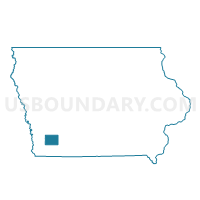
Outline

Summary
| Unique Area Identifier | 582913 |
| Name | LINCOLN TWP Voting District |
| County | Montgomery County |
| State | Iowa |
| Area (square miles) | 35.61 |
| Land Area (square miles) | 35.61 |
| Water Area (square miles) | 0.00 |
| % of Land Area | 100.00 |
| % of Water Area | 0.00 |
| Latitude of the Internal Point | 41.11647800 |
| Longtitude of the Internal Point | -95.32736840 |
Maps


Graphs
Select a template below for downloading or customizing gragh for LINCOLN TWP Voting District, Montgomery County, Iowa


Neighbors
Neighoring Voting District (by Name) Neighboring Voting District on the Map
- ANDERSON TWP Voting District, Mills County, IA
- GARFIELD TWP Voting District, Montgomery County, IA
- GROVE TWP Voting District, Pottawattamie County, IA
- MACEDONIA TWP Voting District, Pottawattamie County, IA
- RED OAK TWP Voting District, Montgomery County, IA
- SHERMAN TWP W/O ELLIOTT Voting District, Montgomery County, IA
Top 10 Neighboring County Subdivision (by Population) Neighboring County Subdivision on the Map
- Red Oak township, Montgomery County, IA (6,124)
- Sherman township, Montgomery County, IA (554)
- Anderson township, Mills County, IA (448)
- Macedonia township, Pottawattamie County, IA (396)
- Garfield township, Montgomery County, IA (197)
- Lincoln township, Montgomery County, IA (157)
- Grove township, Pottawattamie County, IA (155)
Top 10 Neighboring Unified School District (by Population) Neighboring Unified School District on the Map
- Red Oak Community School District, IA (7,118)
- Riverside Community School District, IA (3,951)
- Griswold Community School District, IA (3,434)
- Nishna Valley Community School District, IA (1,334)
Top 10 Neighboring State Legislative District Lower Chamber (by Population) Neighboring State Legislative District Lower Chamber on the Map
- State House District 98, IA (32,864)
- State House District 97, IA (27,696)
- State House District 96, IA (26,979)
Top 10 Neighboring State Legislative District Upper Chamber (by Population) Neighboring State Legislative District Upper Chamber on the Map
Top 10 Neighboring 111th Congressional District (by Population) Neighboring 111th Congressional District on the Map
Top 10 Neighboring Census Tract (by Population) Neighboring Census Tract on the Map
- Census Tract 401, Mills County, IA (3,023)
- Census Tract 217.02, Pottawattamie County, IA (2,101)
- Census Tract 9601, Montgomery County, IA (2,004)